
*Trusted Archival Research Documents in Sequence
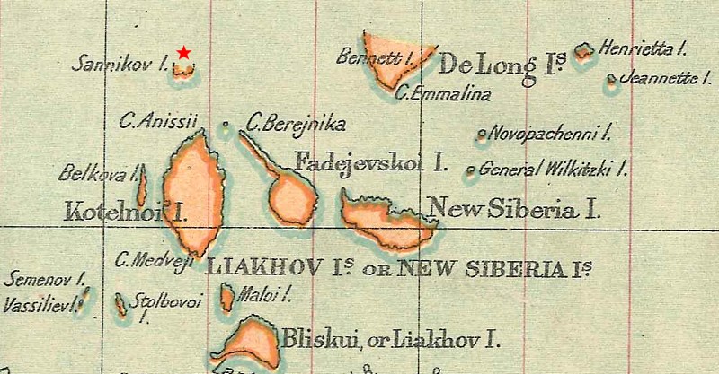
1805: Sannikov Land Spotted
According to a 1925 article in Geographical Review, 1805 was the year Yakov Sannikov observed land directly north of Kotelny Island while exploring the New Siberia Islands. He went public with the discovery, but in the early 1820s, explorer Pyotr Anjou failed to find it. About sixty years later, Eduard Vasilyevich Toll declared he had again spotted what, by then, was called Sannikov Land! It had been during an 1886 expedition, and in 1900, Toll sailed on a ship called the Zayra to confirm the island’s existence. He was unable to do so (and died during the attempt). Neither was it found by Boris Vilkitsky during a 1913-1914 expedition on the Taimyr and the Vaigach. Despite such reports, Sannikov Land is included on a 1910 map, a 1919 one, and on the 1922 Stanford’s General Map of the World (shown below).
1818: Croker Mountains Spotted
On an expedition to find the Northwest Passage, Sir John Ross (1777-1856) commanded the Isabella, accompanied by William Edward Parry (1790-1855) in charge of the Alexander. In Baffin Bay, west of Greenland, Ross arrived at what is now called Lancaster Sound, which would have taken him to the Beaufort Sea and open waters in the west. Instead of a channel, though, he “distinctly saw the land, round the bottom of the bay, forming a connected chain of mountains with those which extended along the north and south sides.” Convinced these mountains formed a blockade — a conclusion challenged by Parry and others there — Ross returned to England.
The error was corrected in 1819, when Parry sailed the Hecla well beyond where Ross had perceived the Croker Mountains. The Princeton University Library offers an illustration and a map reflecting the mountain chain Ross thought he saw.
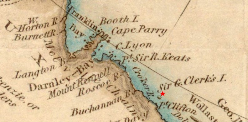
1826: Sir George Clerk’s Island Spotted
While charting the northern coast of Canada and Alaska under John Franklin‘s command, John Richardson spotted “a high island, lying ten or twelve miles from the shore, which received the appellation Sir George Clerk’s Island.” It was mapped (see below), put on nautical charts, and came to be called Clerk Island. However, onboard the H.M.S. Enterprise in 1853, Richard Collison passed by without seeing it. The same report was made by Roald Admunsen as he traveled by in the Gjøa in 1905. Vilhjalmur Stefansson tried to see it by land, as Richardson had, in both 1910 and again in 1911. He also searched for it by sailing on the Teddy Bear and learned that this ship’s captain subsequently “cruised back and forth over the site” — all with no sign of Clerk Island. Oddly enough, Stefansson’s extensive search might have been sparked by his chats with “American whalemen who claim to have seen the island” where the charts said it should be. After weighing the evidence of these efforts in Report of the Canadian Arctic Expedition (1924), Kenneth G. Chipman and John R. Cox call for the removal of Clerk Island from maps, concluding that “it is quite possible that [Richardson] saw dirty ice and mistook it for an island — a mistake easily made.”
1849: Plover Island Spotted
According to Berthold Seeman’s Narrative of the Voyage of the H.M.S. Herald, Captain Henry Kellett spotted, landed on, and raised the Union Jack on Herald Island, named for the ship. This discovery was subsequently confirmed. To the north, the crew spotted more “high peaks,” which they named Plover Island for the ship that had been accompanying them (p. 116). Its existence was not so certain. According to “Report of the Secretary of the Navy,” published in the May 23 1855 issue of the Daily National Era, Commander Rogers of the ship Vincennes attempted to verify land “placed upon Admiralty charts…,” including Plover Island. Rogers was unable to find any such land, despite clear visibility. Even atop the summit of Herald Island, “no land could be seen in any direction, although the horizon was good…. Commander Rogers is of the opinion that the island does not exist, and the Captain Kellett was misled by appearances.”
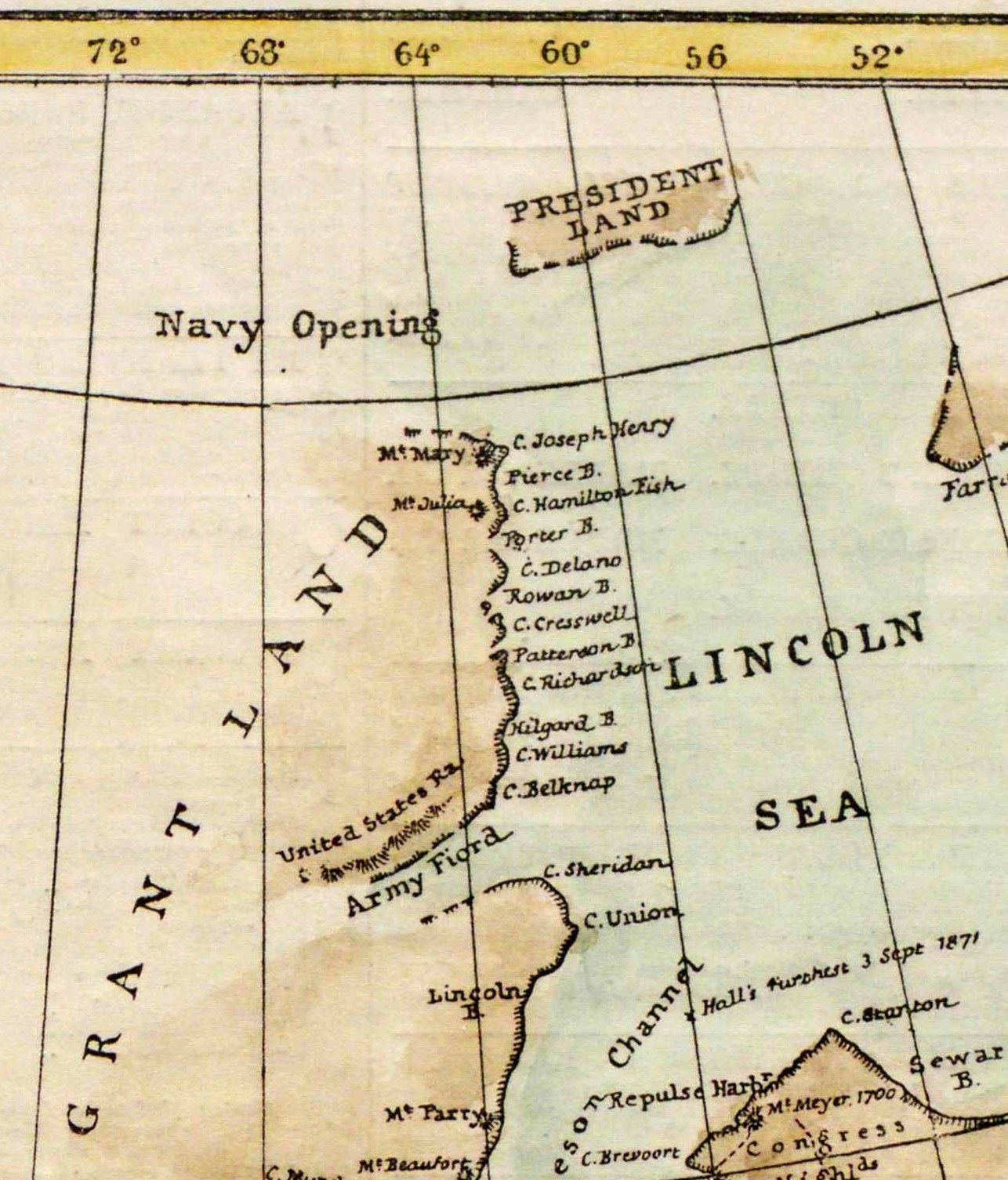
1871: President’s Land Spotted
According to an 1874 article published in the Maritime Monthly, Captain Charles Francis Hall led an Arctic expedition on the Polaris. The journey resulted in claims of sighting what was called President’s Land (a.k.a. President Land or Presidents Land). In 1875, The Illustrated London News printed a map that includes it at the top. A high-quality copy of the map is available at the Internet Archive. However, George Nares led an expedition on the ships Alert and Discovery. Also in 1875, he reported that “with much reluctance [he was] forced to admit that no land existed” where Hall had observed it. The October 28 1876 issue of the New York Herald confirms that the existence of President’s Land, “heretofore indicated on the Arctic maps,” had been proved to be nonexistent.
1880: Kennan Land Spotted
According to the Proceedings of the California Academy of Sciences, Charles Woolcott Brooks read a paper before that society on the topic of Arctic exploration. He mentioned that new land had been discovered north of Point Barrow, Alaska. It was called “Keenan Land” in honor of Captain Keenan, who had spotted it from a distance while on the whaling ship James Allen. Keenan’s observation, Brooks says, is “annually confirmed by the flight of large numbers of aquatic birds,” which migrate north in the spring and return in the late summer. A later report on Keenan’s sighting, published in an 1893 issue of the National Geographic, names the ship the Stamboul.
Ejnar Mikkelsen’s “Report of the Mikkelsen-Leffingwell Expedition” was published in the October 1907 issue of the Bulletin of the American Geographical Society. There, he states:
The Eskimo reports concerning land to the north of Pt. Barrow and the reports about the island which Captain Keenan and several Eskimos thought they saw somewhere to the north and west of Harrison Bay, related probably to the heavy [ice] floe, which, seen in a certain light, conveys the idea of distant land. The fact that the Eskimo reports tell about ’rounded-off hills’ on the land they claim to have seen or visited strengthens this idea, for the old floe has many of these rounded elevations.
According to the August 14 1919 issue of the Omaha Daily Bee, Stork Storkleson had spent six months on an ice floe. He returned with the news that Keenan Land “was found to be non-existent.” A year later, the same conclusion appears in Hudson Stuck’s book A Winter Circuit of Our Arctic Coast, and in an article for Sunset magazine. In the latter, Storkleson is quoted as saying, “There was no sign of [Keenan Land]…. Our drift took us through the territory where it was supposed to be located, but we got soundings of 2970 meters and no bottom.” This reinforced Mikkelsen’s conclusion of the previous decade.
1904: An Arctic Landmass Theorized
Rollin A. Harris proposed a significant Arctic landmass in “Some Indications of Land in the Vicinity of the North Pole,” published in the June issue of the National Geographic. (The article began as a paper read before the Philosophical Society of Washington two months earlier, and later was incorporated into Harris’s book Manual of Tides.) Having collated reports of currents, old ice, and tidal patterns, Harris offers this illustration, marking with horizontal stripes where he thinks land exists:
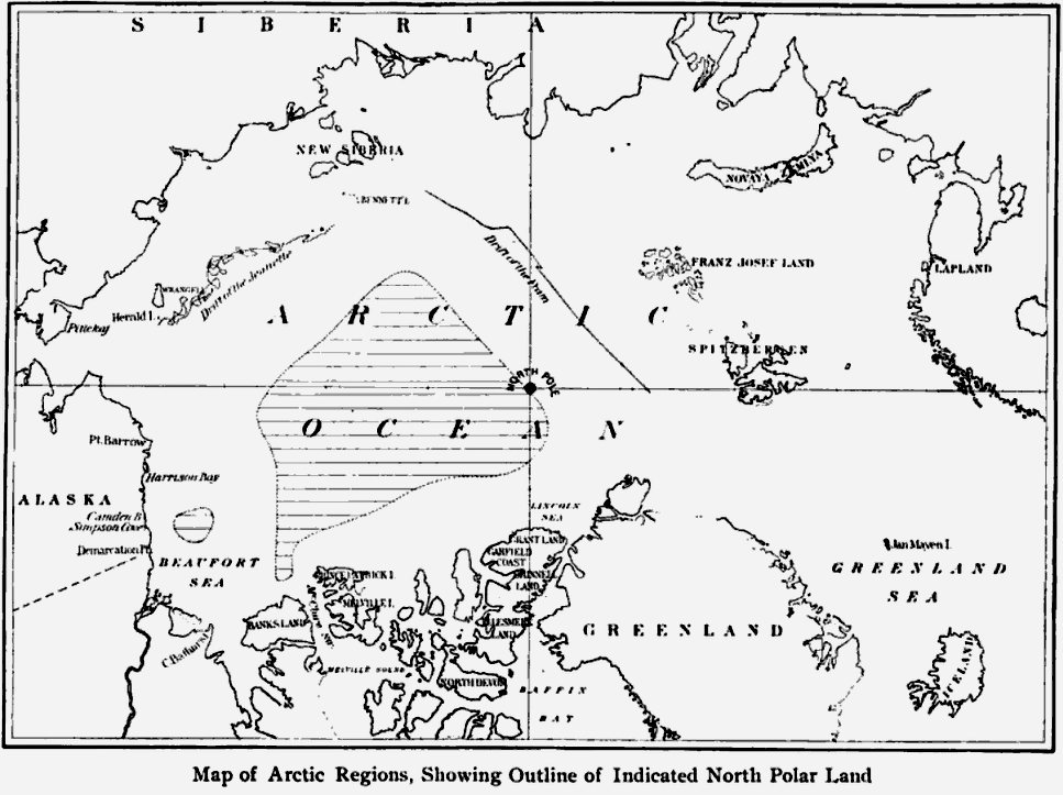
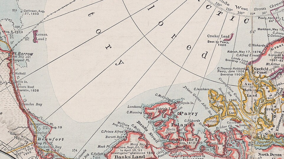
I’m no chartographer, but the map provided by Peary in 1907 — which is below — seems to place Crocker Land in between the southeast coast of the “Indicated North Polar Land” and the northwest coast of Ellesmere Island (noted on Harris’s map as Grant Land/Garfield’s Coast).
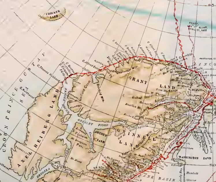
1907: Crocker Land Publicized
Robert Peary’s Nearest the Pole was published. In it, he twice claims to have spotted land to the northwest of Ellesmere Island (a.k.a. Grant Land). On a map included at the end of the book, this spot is designated as Crocker Land.
Aimed at general readers, Peary’s book presumably was available fairly early in the year because reviews appeared in the March 14 issue of Life, the May 16 issue of Independent, and the June issue of Bookman.
Fridtjof Nansen’s “On North Polar Problems” was published in the November issue of the Geographical Journal. It is noted as being a paper read at the Royal Geographical Society on April 29th of the same year, and it seems reasonable to assume that Nansen makes no mention of Crocker Land simply because he hadn’t heard of it yet. Instead, after listing discoveries made by several explorers, Nansen states: “There is, in fact, no known land in the north whose northern coasts are not now explored” (p. 470).
Edwin Swift Balch’s “Crocker Land” was published in the December issue of the Bulletin of the American Geographic Society. In this short article, Balch says that Peary’s discovery of Crocker Land disproves Nansen’s statement about no unexplored land left. He praises Peary as being “the greatest of Arctic explorers and the greatest of sledgers” and affirms Harris’s theory of a significant landmass yet to be confirmed (see 1904). Nansen and Harris are often mentioned as representing opposite sides of the debate on Crocker Land’s existence.
1909: Bradley Land Publicized and Crocker Land Supported
Frederick Cook’s series of articles about his 1907-08 journey to the North Pole was published in the New York Herald and reprinted in other papers. In the ninth installment, Cook claims to have spotted land: “The fog, which had persistently screened the west, had vanished, and land was discovered at some distance west, extending parallel to the line of march.” He adds, “The land as we saw it gave the impression of being two islands, but our observations were insufficient to warrant such an assertion. They may be islands, they may be part of a larger land extending far to the west…. The lower shore line was at no time visible. This land is probably a part of Crocker Land.” Shortly after, he says, “We were eager to set foot on the newly discovered coast, for we believed then, as proved by later experience, that these were earth’s northernmost rocks, but the pressing need for rapid advance in the aim of our main mission did not permit detours.” In the tenth installment, the headline reads: “NAME OF BRADLEY LAND GIVEN TO ELUSIVE SIGNS OF NEW-FOUND REALMS.” Cook’s naming of the land was to honor John R. Bradley, one of his expedition’s financial backers.
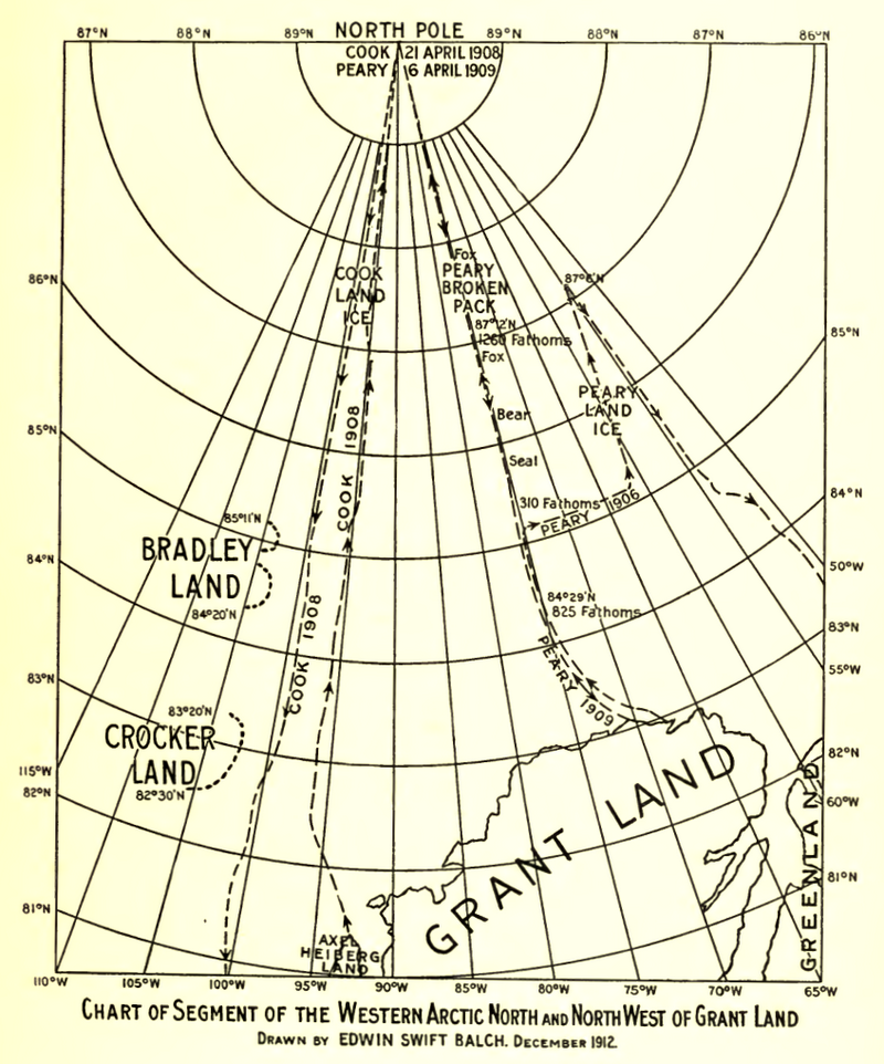
An article titled “NEW COOK SKEPTIC – NEW LAND MYTH – ‘Open to Scientific Improbability’” was published in the New-York Tribune. The skeptical scientist featured there is J.W. Spencer, member of the Geological Survey and specialist in continental shelves and submarine canyons. Spencer explains that the point where Cook claimed to have seen Bradley Land is very likely too far off the continental shelf to be actual land. In addition, based on an analysis of one of Cook’s photographs, “the Canadian scientist concludes that Bradley Land is ‘a myth.'” Cook’s curious parallel to Peary’s claim about Crocker Land was met with swift denial.
1911: Crocker Land Accommodated and Bradley Land Qualified
Rollin A. Harris’s Arctic Tides was published. Seven years earlier, Harris had proposed a significant tract of Arctic land (see 1904). Maintaining that view, Harris now reiterates his hypothesis that there is a body of Arctic land, one “trapizodial in form” and covering “nearly half a million square statute miles.” Crocker Land, he says, sits at one of its corners (pp. 90-92). His new map now accommodates this:
Frederick Cook’s My Attainment of the Pole was published. As he had in his 1909 newspaper series, he recounts successfully reaching the North Pole and, on the way there, discovering Bradley Land in March of 1908. Cook says:
As well as I could see, the land seemed an uninterrupted coast extending parallel to the line of march for about fifty miles, far to the west. It was snow covered, ice-sheeted and desolate. But it was real land with all the sense of security solid earth can offer…. Now came, of course, the immediate compelling desire to set foot on it, but to do so I knew would have side-tracked us from our direct journey to the Polar goal. (p. 244)
Cook also qualifies the sighting by adding on the next page: “This new land was never clearly seen.” After that, he explains that he told his crew that they might be able to explore it on the way back from the pole, but he regrets, “We never saw it again.”
1913: Crocker Land Sought
On June 8, Vilhjalmur Stefansson departed from Victoria, Bristish Columbia, on the Karluk. Funded by the Canadian government, Stefansson’s plans included seeking Crocker Land from the west. An article in the July 1 issue of the Evening Times-Republic, a newspaper in Marshalltown, Iowa, reports that Stefansson was hoping to return in October of 1916.
On July 3, Donald MacMillan departed from New York on the Diana. Funded by the American Museum of Natural History and the American Geographical Society, MacMillan’s chief plan was to seek Crocker Land from the east. An article in the July 3 issue of the Cairo Bulletin, a newspaper in Illinois, reports that the explorers were scheduled to return in “the fall of 1915.”
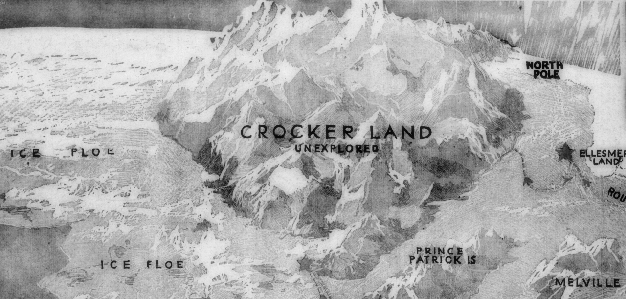
Titled “New Search for a Polar Continent,” an article in the July 27 issue of the San Francisco Call discusses the Stefansson and MacMillan expeditions. The piece includes this imaginative depiction of Crocker Land.
1914-1915: Crocker Land Judged a Myth and a Mirage
On November 23, a letter arrived at the American Museum of Natural History. In it, expedition member Walter Ekblaw says MacMillan and Fitzhugh Green travelled in the direction of Crocker Land and — after experiencing what they later deemed to be a mirage of distant land — “they finally concluded that Crocker Land does not exist, at least not within the range originally ascribed to it.” The front page of the November 25 issue of the New-York Tribune reads: “CROCKER LAND ELUDES EXPLORERS.” The MacMillan expedition, the article says, found that “Crocker Land has either melted or moved from the position it was supposed to hold.” The next day, the front page of the Evening Times-Republican, a newspaper in Marshalltown, Iowa, proclaimed: “CROCKER LAND A MYTH. Polar Expedition Fails to Find Land Peary Said He Sighted.” This certainly marks a significant first step in disproving the existence of Crocker Land.
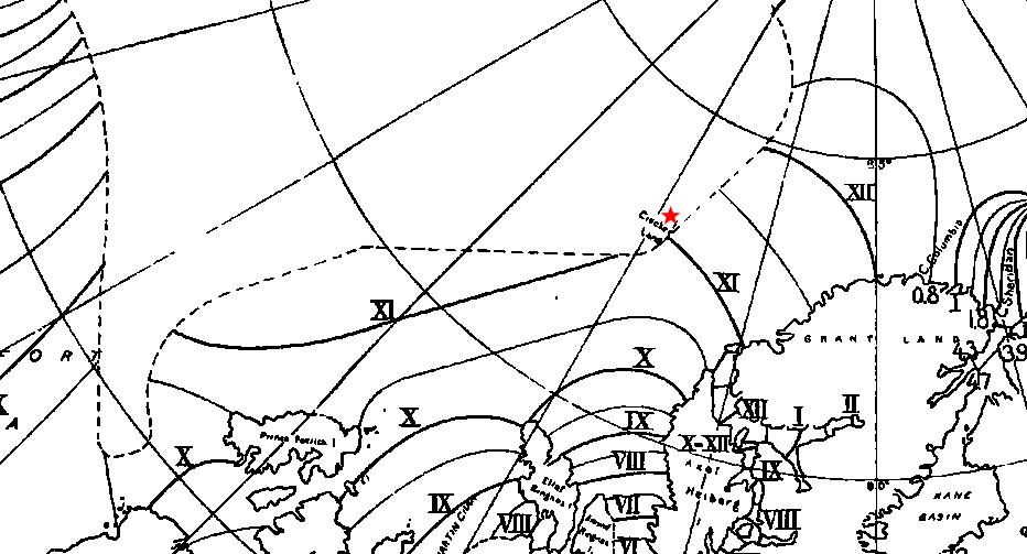
Donald MacMillan’s two-part article “In Search of a New Land” was published in the October and November 1915 issues of Harper’s Monthly. It includes this map:
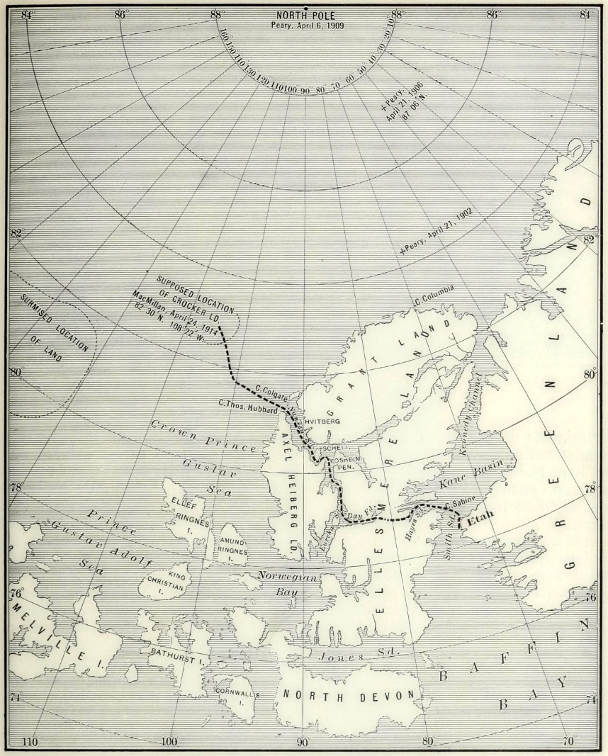
In this firsthand narrative, MacMillan publicly recounts how, on April 21 1914, he and Fitzhugh Green thought they could see land. Their Inuit companion dismissed it as mist, though. MacMillan continues:
As we proceeded it gradually changed its appearance and varied in extent with the swinging around of the sun, finally at night disappearing altogether…. Could Peary with all his experience have been mistaken? Was this mirage which had deceived us the very thing which deceived him eight years ago? If he did see Crocker Land, then it was considerably more than one hundred and twenty miles away, for we were now at least one hundred miles from shore, and nothing in sight.
Days later, upon returning to the same spot where Peary claims to have seen Crocker Land, MacMillan looked out — and again saw land!
Yes, there it was! It could even be seen without a glass extending from southwest true to north-northeast. Our powerful glasses, however, brought out more clearly the dark background in contrast with the white, the whole resembling hills, valleys, and snow-capped peaks to such a degree that, had we not been out there for one hundred and fifty miles, we would have staked our lives upon it. Our judgment then as now is that this was a mirage or loom of the sea ice.
The implication here — and it’s a strong one — is that Peary likewise was the victim of a visual deception.
1916: Crocker Land — and Peary — Opposed
Henry T. Helgesen, Representative from North Dakota, spoke before the House to argue that government-issued maps of the Arctic be corrected. Among the changes, he argues for the removal of Crocker Land, saying that the MacMillan expedition “now proves it to have been only an imaginary dream” (p. 11).
Edwin Swift Balch’s letter to the editor titled “The Present Status of the North Pole Question” was published in the March 18 issue of Scientific American. Reversing his earlier support of Crocker Land (see 1907), Blach says that “the fact that Peary was deceived by a mirage into believing that there was a land which he called Crocker Land shows that there is a possibility that Cook was also deceived by a mirage into believing there is a land which he called Bradley Land.”
The August 26 issue of Washington D.C.’s Evening Star (along with other papers across the nation) reported that Peary was still confident that Crocker Land would be proven to exist. Fitzhugh Green — who had accompanied MacMillan when deciding Crocker Land was not where Peary had said — finally returned from the expedition. He had no news about Crocker Land’s discovery. This merely reinforces what already had been reported (see 1914). Nonetheless, Peary is quoted as saying, “It will be well to await the completion of Stephansson’s discoveries before dismissing Crocker Land.” Even five years later, Stephansson himself — who also had found no evidence of it — still wouldn’t be ready to dismiss Crocker Land, either (see 1921).
On September 24, an article titled “Has the North Pole Ever Really Been Discovered?” appeared in the Richmond Times-Dispatch. It included this map:
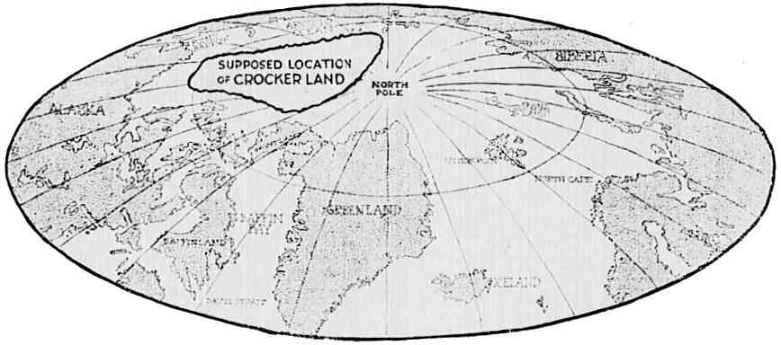
The illustration appears with this caption:
Map of Crocker Land Which Peary Claimed to Have Discovered in 1906. In 1913, an Expedition Sent Out by the American Museum of Natural History to Explore Crocker Land Reported That There Was No Such Place. The Site of the Supposed Crocker Land, They Said, Was a Broad Expanse of Polar Sea! Upon the Strength of This Development, Suspicion Has Been Levelled Against All Peary’s ‘Discoveries’ Including That of the North Pole!”
If Peary was mistaken or misleading in his claim to have seen Crocker Land, then his assertion that he had reached the North Pole might also be unreliable. Public opinion of Peary was turning sour.
1921: The History of Mapped Mirages Discussed
An article titled “Plover Land and Borden Land” was published in April issue of The Geographical Review. Explorer Vilhamer Stefansson writes about the history of Arctic lands that had been reported, placed on maps, and then proven to not exist. His examples are Clerk Island, Sannikov Land, and Crocker Land. However, he says, “It seems to me that Crocker Land should still be granted a period of grace.” MacMillan found no land where Peary had reported it, but no soundings were taken, according to Stefansson. He adds that his own soundings taken during 1917 revealed a level shelf extending from land “for 150 miles as we traveled toward Crocker Land.” He recommends that “we let Crocker Land bide till the vicinity is sounded and shown to be deep water, or till the region is explored so thoroughly that we know it is not merely hiding.” The rest of the article explores the strange phenomena of seeing land that isn’t there and not seeing land that is. Stefansson’s main example is Plover Land, which he suggests might be “one and the same” as Borden Land (pg. 291). The latter is a verified island discovered during the Canadian Arctic Expedition of 1913–16.
1926: The Arctic Explored by Dirigible
The headline of the May 17 1926 issue of the Alaska Daily Empire reads: “AMUNDSEN DISCOVERS NO LAND ON FLIGHT OVER ARCTIC.” Roald Amunsen and others had crossed the Arctic on the dirigible Norge. Though a later source suggests “they were perhaps too far west” to have seen Crocker Land unless it were part of a very large landmass, this shift to the skies marks a significant change from seeking unverified Arctic lands at sea- and land-levels.
1928: The Arctic Explored by Airplane
George H. Wilkins flew across the Arctic by plane, a trip he had hoped to make two years earlier. According to the January 10 1926 issue of the Evening Star, his original plan was to prove or disprove the existence of Crocker Land, Keenan Land, and Bradley Land. That article says Wilkins “may put Keenans Land [sic] and Crocker Land back on the maps again. He may put them off the maps permanently.” Keenan Land probably wasn’t much of a concern, since it had been confirmed as non-existent in 1920. However, Wilkins did help settle two other important issues. According to the September 16 1928 issue of the Evening Star, Wilkins’ flight “has changed the map of the world by eliminating Crocker Land and Bradley Land.”
1938: Crocker Land Settled
Isaac Schlossbach returned from the MacGregor Arctic Expedition. He was reported to say that, despite twenty flights over where Peary had placed it, “There simply isn’t any Crocker Land.”

