
A Pattern of Misperception
Let’s review. Plover Land, President’s Land, Keenan Land, Crocker Land, and Bradley Land. These are all Arctic islands reliable explorers claimed to have observed in the 1800s and early 1900s. Except for Plover Land, I’ve found them all on maps assumed to be reasonably accurate. But there’s a problem. Subsequent expeditions couldn’t verify the existence of these places — on the contrary, no land at all appeared where they had been reported to be — and the decision was eventually made that none of these islands exist! They no longer appear on maps.
I don’t know for sure why I find this interesting. It fits perfectly with the usual path of scientific progress: a researcher puts forth a claim — in this case, hey, there could be some land in this spot! — and other researchers then go to work to support or challenge that claim. With ongoing verification, the claim advances in validity. Frequently, though, it’s eventually disproved. So why am I intrigued by this pattern of polar misperception? Do these phantom islands qualify as ghosts of a different kind? Is it an illustration of how, under certain circumstances, we should be very careful about trusting our own eyes? Is it a reminder that reality is flexible and funny?
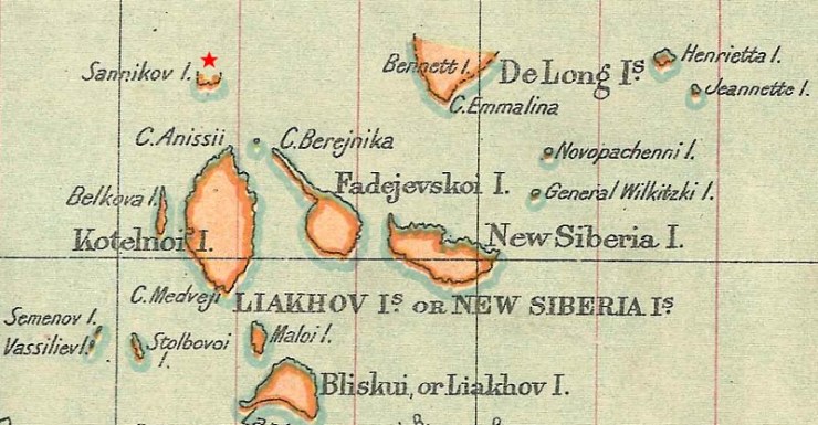
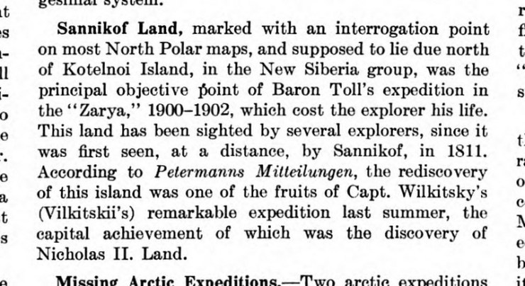
Whatever the answer, last week, I added another example of this history to my Crocker Land and Other Mapped Mirages of the Arctic page. Sannikov Land was named for the man who first observed it: Yakov Sannikov, a.k.a. Яков Санников, a.k.a. Jacob Sannikoff. This theoretical land, said to lie directly north of Kotelny Island in the New Siberian archipelago, wavered between being there and not being there for over a century. It’s a somewhat complicated history, and it’s a bit tricky to chart the specifics of it. But I’m going to give it a try.
Sannikov Land Was There, Not There, There, and Not There
One of my best sources of information is Baron Edward Toll’s “Proposal for an Expedition to Sannikoff Land,” translated and published in an 1898 issue of The Geographical Journal. Toll was a Russian explorer who had claimed to have seen the island before making his proposal to hunt for it, so he might be biased in favor of it existing. Nonetheless, he dates Sannikov’s original sighting between 1805 and 1811. This was followed by attempts to verify the island by Petr Anjou in 1821-23. While acknowledging the difficulties of exploration in that region, Anjou declared that he couldn’t find what Sannikov had seen. Already, the reality of Sannikov Land was in doubt, and Toll says “it disappeared from maps.”
Despite Anjou’s challenge, continues Toll, Sannikov had made a similar claim about what would become called Bennett Island off to the northeast, a claim that was verified in 1881. And local hunters said there is land north of Kotelny Island. And on an 1886 expedition, “during quite clear weather,” Toll himself peered where Sannikov had done so decades earlier and observed “the sharp outlines of four truncated cones[,] like table mountains, from which a low foreland extended towards the east.” The ice had prevented him from reaching the spot at that time, but Toll was inspired to organize a formal search for the island. He even hoped to camp there for a winter.
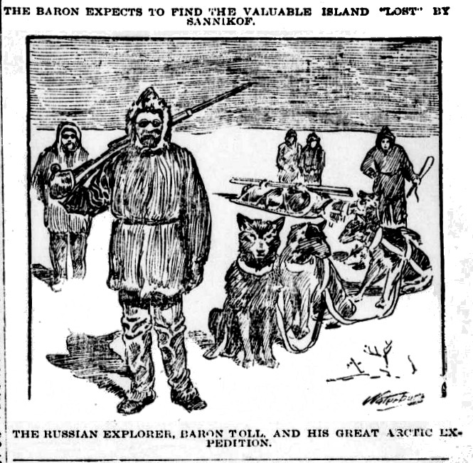
For information on how that expedition turned out, we must turn to other sources. First, The Geographical Journal reported in its April 1902 issue that Toll’s ship, called the Zarya, “passed the supposed position of Sannikof Land without gaining sight of it; so that it must either lie farther north than has been supposed, or have no existence.” Later that year, as Helen S. Wright explains in her book The Great White North (1910) — after Toll had been “[d]isappointed in his hopes of reaching Sannikof Land” — he and a few colleagues never returned to the Zarya after going on an excursion to Bennett Island. Given how important confirming the existence of the island was to Toll and to the expedition that took his life, things looked bleak for verification of Sannikov Land.
Another Expedition, Another Refutation
In 1913, Boris Vilkitsky led an Arctic expedition on the Taimyr and the Vaigach, two ice-breakers. This expedition put the Severnaya Zemlya archipelago — dubbed Nicholas II Land by Vilkitsky — on the map, which was pretty amazing considering how much exploration had been done by that year. (One website calls it “the Last Charted Territory on Earth.”) I can’t find any evidence that settling the Sannikov Land issue was among Vilkitsky’s main goals, but his ship’s log for August 21 reports this: “There had been clear water all these days and a clear horizon, but we had seen nothing of the conjectured Sannikov Land.” This carried weight in making a final decision.
In the wake of the Taimyr and the Vaigach, Sannikov Land was on its way to vanishing for good. In a 1921 article for Discovery magazine, R.N. Rudmose Brown declares, “We are probably justified in saying it does not exist.” That same year, in the pages of The Geological Review, Vilhjalmer Stefansson put it among those places that, after being reported by credible Arctic explorers, “have kept their places on the chart for one or several generations, but are now gone forever.”
It’s interesting to see how the final days of Sannikov Land overlapped with Robert Peary’s 1907 claim of having spotted Crocker Land and Donald MacMillan’s 1913-1917 Crocker Land Expedition, which played a major part in invalidating Peary’s claim. There are good reasons why some people accuse Peary of having faked his discovery in order to secure more funding. Before passing judgment, though, it’s wise to remember the history of claims about having observed an Arctic island that were afterward determined to be false. Not falsified, mind you. Simply false.
As I say, the Sannikov Land story is now noted on my timeline titled Crocker Land and Other Mapped Mirages of the Arctic. I made some additional changes that will hopefully make things easier to follow there. You can also find lots more related stuff on Charting Crocker Land (Base Camp).
— Tim

